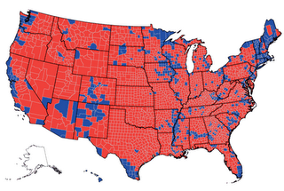
With the U.S. map politically polarized—northern and western states blue and southern ones red, with little bipartisan activity—Mills said he is 15-20 percent confident that America could face another Civil War if the 2008 election is as closely contested as the past two.
“I looked at the map of the last two elections and it looks a whole lot like the map of the U.S. just prior to the Civil War,” he said.
Predicting a new civil war is just silly, regardless of what the maps show. But a look at the maps shows no similarity between 1860 and 2004. Below are county level maps for the1860 and 2004 elections. The 1860 map is a bit hard to read, but you can see that the country was cleanly divided between north and south. In 2004, however, you can find Democrats and Republicans all around the country.


One common measure of geographic segregation is the index of dissimilarity. The index ranges from 0 to 100 and measures the percentage of a particular group that would have to move in order to be evenly distributed across each unit of analysis. For example, in a county-level analysis of blacks and whites, an index of dissimilarity of 20 means that 20 percent of whites would have to move to a new county in order for each county to have the same proportion of whites and blacks.
The index of dissimilarity in 1860 between Republicans and non-Republicans (the Democratic vote was split 3 ways) was 46. This means that 46 percent of Republicans would have to move to a new county in order for them to be evenly distributed across all counties. A quick look at the map above indicates that pretty much half of all Republicans would have to move out the north and into the south for an even distribution.
In 2004, by contrast, the index of dissimilarity for Republicans and Democrats was only 22. By this measure, geographic polarization today is only half what it was in 1860.
2 comments:
That's almost as ridiculously alarmist as predicting two million people could die of the bird flu.
Well, there is also no issue on which most of any section of the Country is willing to fight. (Its not a graph or anything but it has the advantage of being true). We in Virginia plan to defend our soil robustly should the big taxers come our way, but are making no aggressive moves North this time. South Carolina on the other hand has asked for free passage so it can just fight Massachusetts.
Post a Comment